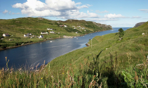
Gravir
The largest village in the Pairc area of South Lochs, once supporting a population of 468 (in 1911) although in 2005 the population was only 76.
Gravir (Grabhair): Norse for “pits, graves” (according to James B Johnston, Place-Names of Scotland). D Maciver, Placenames of Lewis and Harris, suggests a meaning closer to “dig”, from the Norse grof, grafir, and notes that there are “about 70 streams in Lewis named gro, meaning wearing out the river bed.”
The march boundary is described thus:
Commencing on the east of Clach Uilleam in Loch Odhairn, from thence to Loch nam Faoileag from thence to Loch na Ba Ruaidhe and from thence to the top of Tom a Ghruagaich from thence to the top of Goideal Bheag and from thence by Gleann Carn Aonghais to Loch nan Iolairean and from thence to Liana na Duch at the head of Amhuinn Ceann Loch Odhairn and from thence by Aullt Loch Chachan Dearca and from thence to Loch an Eilean Duibh and from thence to the west end of Loch Gaineamhaich and from the east end of Loch Gaineamhaich in a straight line to the top of Sithean Doun and from thence to Loch an Leomhann and from thence by Aullt Loch nan Leomhann to the sea.
The earliest history of Gravir starts sometime well before 1800 and possibly as early as 1766, with the village increasing in size as the run-rig system was abolished between 1850 and 1852. Some references go back to 1766 and it may be that this is when the first residents moved to the area. Oral tradition suggests that the first residents moved from Lite-Sithinn to the east end of Gravir, reaching as far as the Gill at what is now croft 14. Around that time, the same oral tradition suggests that Robert Weir was the Tacksman for both Gravir and Calbost.
Originally there appears to have been 30 crofts but another 4 were added during the 19th century, two at each end of the village. On the south side of the loch, the clachan of Tom an Fhuadain was established before 1800 and grew to a further 9 crofts.
The village was predominantly a fishing community, established round both sides of Loch Odhairn and the name is of Scandinavian origin, meaning graves or pits. There is a large gap in the history of some of these villages in Pairc between the early Norse settlers who were in control in the Western Isles from AD850 till around 1266 and the 1700s but the settlement names and the Norse mills somehow continued through the ages.
In 1934 a further 15 crofts, or more accurately Fishermen’s Holdings, were added when the Dept of Agriculture purchased the Glen Gravir area from the estate. The land in Glen Gravir has crofting rights but no access to the Common Grazing.
Gradually the population of Gravir increased to its peak of 468 registered in the 1911 census but sadly since then, the population has declined steadily. The village was the largest in Pairc in terms of population and number of crofts which are stated as “43 legal crofts and a further 15 at Glen Gravir” in Dr Caird’s study of 1958. The croft numbers go up to 44 but there is no croft numbered 41. It did exist but has been merged into another croft.
Booklet available.
Gravir genealogy on Hebridean Connections.
